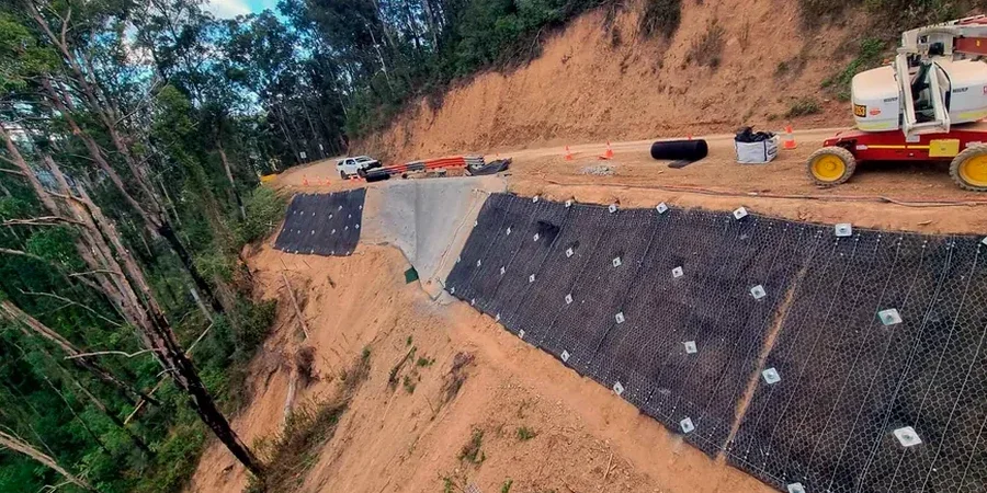
On the North Shore, slope instability isn't a theoretical exercise — it's a daily reality. We've seen too many projects stall because someone assumed a cut in glacial till would hold through a wet November. North Vancouver's terrain rises sharply from sea level to over 1,400 meters in just a few kilometers, creating some of the steepest urbanized slopes in Canada. When you're developing on a lot backing onto Lynn Creek or building near the bluffs above Deep Cove, a proper slope stability analysis is the difference between a permitted project and a stop-work order. We combine field reconnaissance with limit-equilibrium modeling to quantify the factor of safety under both static and seismic conditions, because the District's geotechnical review won't accept guesswork. For deeper soil profiles we often pair the analysis with SPT drilling to correlate shear strength parameters with actual penetration resistance, which gives the model real numbers instead of textbook assumptions.
A slope that stands today can fail tomorrow when groundwater conditions change — stability is a state, not a property.
Local considerations
North Vancouver's development history is written into its slopes. The post-war boom pushed subdivisions up onto terrain that the original townsite avoided — the steep draws between Lonsdale and Lynn Valley, the bluffs above Marine Drive. Today those areas hold some of the most valuable real estate in the region, but they also concentrate risk. A landslide on a single lot can cascade: debris reaches a creek, the creek undercuts a road, and suddenly the District is managing an emergency. We've reviewed historical air photos showing slope movements that predate current zoning maps, and that context feeds directly into the hazard assessment. The analysis doesn't just produce a number — it identifies whether a slope is creeping, whether a wet winter will trigger a translational failure, and whether the consequence classification per the District's Slope Hazard Assessment criteria demands engineered stabilization. In North Vancouver, a stability report is often the document that keeps an insurance policy valid.
Frequently asked questions
Does the District of North Vancouver require a slope stability analysis for my building permit?
If your property has slopes steeper than 30 percent or lies within a mapped Slope Hazard Area under the District's Official Community Plan, yes. The District's geotechnical review process typically requires a report signed by a Professional Engineer registered with Engineers and Geoscientists BC. We prepare submissions that address the specific checklist items from the District's Development Application guidelines, including global and bench-scale stability, setback recommendations, and drainage management.
What does a slope stability analysis cost for a single-family lot in North Vancouver?
For a typical residential lot on the North Shore, a slope stability analysis ranges from CA$1,910 to CA$6,280 depending on slope height, access complexity, and whether subsurface investigation (drilling or test pitting) is required. Simple desktop reviews for relatively flat sites with minor slope elements fall at the lower end. Sites requiring helicopter access or extensive instrumentation push toward the upper range.
How long does a stability analysis take from start to finish?
A straightforward residential slope assessment with site visit and modeling typically takes three to four weeks. If drilling is required for strength parameter confirmation, add two to three weeks for field work and lab testing. We coordinate the drill crew, lab schedule, and report preparation to keep the timeline predictable, and we can often provide preliminary findings within two weeks to keep your project moving.
What's the difference between a factor of safety and probability of failure?
A factor of safety is a deterministic ratio — resisting forces divided by driving forces — calculated for a specific slip surface under assumed conditions. Probability of failure accounts for variability in soil strength, groundwater levels, and seismic loading. On North Vancouver slopes where glacial till and glaciomarine silt properties vary significantly over short distances, we often report both. A slope with FS=1.3 might carry a 5 percent probability of failure if the strength parameters have high uncertainty, and that distinction matters for risk management decisions.