← Home · Laboratory

Grain Size Analysis (Sieve + Hydrometer) for North Vancouver Soils

Together, we solve the challenges of tomorrow.

LEARN MORE →

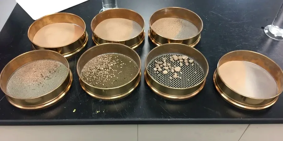
There’s no single ‘North Vancouver soil.’ Drill into the Capilano Highlands and you’ll hit dense glacial till with cobbles that rattle a split spoon. Move down toward the marine benches near Lower Lonsdale, and the borehole logs shift to soft, grey silts laid down when the shoreline was 100 metres higher. This contrast is exactly why a grain size analysis—run properly with both sieve stacks and a hydrometer—isn’t just a lab formality. It’s the first clue to how the ground will behave under load, how it drains, and whether it’s susceptible to liquefaction in a Cascadia event. In our North Vancouver lab, we combine ASTM D6913 for the coarse fraction and ASTM D7928 for fines, delivering a full particle-size distribution that feeds directly into bearing capacity, drainage design, and seismic classification under the NBCC. When the gradation curve straddles sand and silt, we often run parallel Atterberg limits to nail down the plasticity, and for deeper strata where the fines percentage changes with depth, a CPT log gives us a continuous profile to compare against the lab results.

A single hydrometer reading at the two-hour mark can change the liquefaction classification from susceptible to non-susceptible under NBCC 2020.

Process and scope

North Vancouver’s bedrock is Cretaceous granodiorite of the Coast Plutonic Complex, but most residential and commercial sites sit on Quaternary deposits that range from ablation till to glaciomarine stony clay. The till—common above the 200-metre contour—is an unsorted mix of sand, silt, and angular clasts that often plots as well-graded gravel with sand (GW-GC) under the Unified Soil Classification System. Its low fines content and dense fabric generally mean high friction angles and excellent bearing capacity. The glaciomarine deposits, however, are a different story: they can contain 40–70% silt and clay, producing a fine-grained tail in the hydrometer analysis that controls permeability and consolidation rate. A full sieve-plus-hydrometer run quantifies this tail precisely, giving us D10, D30, and D60 values for Hazen’s permeability estimate and the Cu/Cc coefficients needed for filter design. The analysis also flags gap-graded soils—surprisingly common in colluvial fans below the cutbanks of Lynn and Seymour creeks—where internal erosion risk becomes a design consideration for drainage systems. For projects near escarpments, we cross-reference the gradation with slope stability models, because pore-pressure buildup in silty layers has triggered shallow failures on the North Shore during heavy rain-on-snow events.
Grain Size Analysis (Sieve + Hydrometer) for North Vancouver Soils
Technical reference image — North Vancouver

Local considerations

North Vancouver’s build-out history adds a layer of geotechnical risk that gradation data helps manage. From the 1950s through the 1980s, large tracts of the Lower Capilano and Norgate areas were developed over former swamp and intertidal flats using uncontrolled fill. Boreholes in these neighbourhoods routinely encounter 2 to 4 metres of heterogeneous sandy silt with organic lenses, underlain by natural marine clay. Without a grain size curve, a designer might assume a free-draining subgrade; with it, the 30% clay fraction tells you to expect low permeability and long consolidation times. The hydrometer data becomes critical for estimating settlement rates under fill surcharge. Another risk pattern we see repeatedly: steep creekside lots where colluvium contains a matrix of silty sand that plots in the ‘most liquefiable’ band on a Tsuchida curve. Running the full sieve-plus-hydrometer analysis on these samples gives the fines content and D50 needed for a defensible liquefaction screening per NBCC 2020, avoiding both over-conservatism and under-design.

Need a geotechnical assessment?

Reply within 24h.

Email: info@geotechnicalengineering.vip

Technical data

ParameterTypical value
Sieve range75 mm to 75 µm (ASTM E11 sieves)
Hydrometer methodASTM D7928 – 152H hydrometer, dispersant
Minimum sample mass500 g for fine-grained; 2 kg for granular
Dispersion protocolSodium hexametaphosphate, 16-hour soak
Gradation parameters reportedD10, D30, D60, Cu, Cc, % gravel/sand/silt/clay
Classification standardASTM D2487 (USCS) – dual symbol where applicable
Turnaround time5–7 business days for full combined analysis

Complementary services

01

Combined Sieve and Hydrometer (Full Curve)

From 75 mm gravel to 2-micron clay. Includes sample preparation, washing over No. 200 sieve, oven drying, mechanical sieve shaking, and 24-hour hydrometer sedimentation series. Delivered with semi-log plot and USCS classification.

02

Liquefaction Screening Package

Grain size analysis paired with Atterberg limits and water content, targeting the fines content and plasticity criteria in NBCC 2020. We flag samples that fall within Tsuchida’s contractive sand envelope.

03

Filter and Drainage Gradation Design

Cu, Cc, and D15/D85 ratios computed from the gradation curve to evaluate filter compatibility between drain rock and native soil, per Terzaghi’s filter criteria. Common for retaining wall drainage systems on sloped North Shore sites.

04

Forensic Gradation on Existing Fill

For distressed structures in older North Vancouver neighbourhoods, we run gradation on samples from test pits to identify poorly compacted or gap-graded fill as a root cause of differential settlement.

Applicable standards

ASTM D6913/D6913M-17 – Standard Test Methods for Particle-Size Distribution (Gradation) of Soils Using Sieve Analysis, ASTM D7928-21 – Standard Test Method for Particle-Size Distribution (Gradation) of Fine-Grained Soils Using the Sedimentation (Hydrometer) Analysis, ASTM D2487-17e1 – Standard Practice for Classification of Soils for Engineering Purposes (Unified Soil Classification System), NBCC 2020 – Division B, Part 4 – Seismic Design provisions referencing liquefaction susceptibility criteria, CSA A23.3-19 – Design of Concrete Structures (aggregate gradation requirements)

Frequently asked questions

What does a combined grain size analysis cost in North Vancouver?

For a single sample requiring full sieve stack plus hydrometer, the lab fee runs between CA$160 and CA$230, depending on whether we’re dealing with a clean granular soil (faster) or a clay-rich silt that needs extended sedimentation readings. Volume pricing applies for multi-borehole projects.

How much sample material do you need for the test?

We ask for at least 500 grams for fine-grained soils and 2 kilograms for sands and gravels. The mass matters because ASTM D6913 requires a minimum dry mass based on the maximum particle size—if we’re sieving 50 mm cobbles, we need enough material to split a representative fraction without bias.

Can you run the hydrometer on just the fines fraction?

Yes, and we do it frequently. After washing a bulk sample over the No. 200 sieve, we oven-dry the retained material for the coarse sieve stack and run the hydrometer solely on the minus-75-micron suspension. The two datasets are then stitched mathematically into one continuous gradation curve.

Location and service area

We serve projects in North Vancouver and surrounding areas.

View larger map